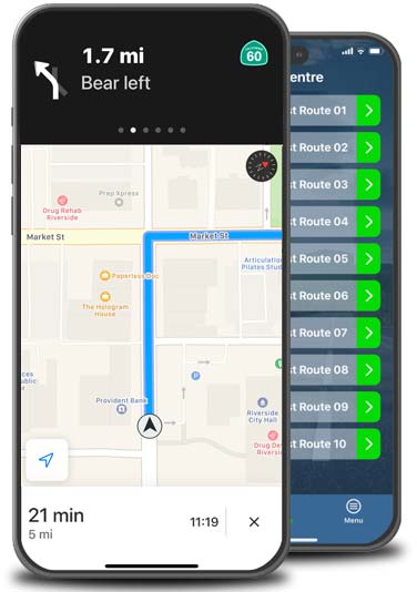
Practice REAL
South Charlotte DMV test routes.
Start Today!


Charlotte Road Test Route Map 01 (Mock)
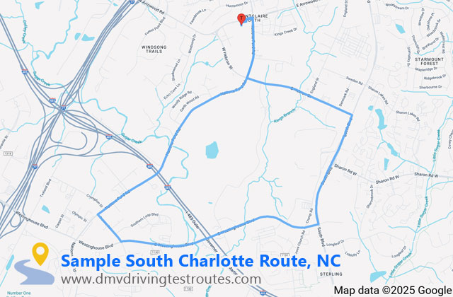
10.20 miles
Length14.00 mins
Duration1 / 5
Route No.| # | Instruction | Distance | Duration |
|---|---|---|---|
| 1 | Head north towards W Arrowood Rd Restricted-usage road |
0.06 miles | 29 sec |
| 2 | Turn left towards W Arrowood Rd Restricted-usage road |
0.01 miles | 12 sec |
| 3 | Turn right onto W Arrowood Rd | 0.05 miles | 21 sec |
| 4 | Turn right onto Nations Ford Rd | 0.46 miles | 1 min 9 sec |
| 5 | Turn left onto E Hebron St | 0.06 miles | 13 sec |
| 6 | Head east on E Hebron St towards Hebron Commerce Dr | 0.79 miles | 1 min 35 sec |
| 7 | Turn right onto South Blvd | 0.05 miles | 8 sec |
| 8 | Head south on South Blvd towards Crump Rd | 0.54 miles | 1 min 16 sec |
| 9 | Head south-west on South Blvd towards E Westinghouse Blvd | 0.29 miles | 34 sec |
| 10 | Turn right onto E Westinghouse Blvd | 1.55 miles | 2 min 34 sec |
| 11 | Turn right onto Downs Rd | 0.27 miles | 43 sec |
| 12 | Turn right onto Nations Ford Rd | 0.39 miles | 48 sec |
| 13 | Head north-east on Nations Ford Rd | 0.94 miles | 1 min 25 sec |
| 14 | Head north-east on Nations Ford Rd towards Old Nations Ford Rd | 0.73 miles | 1 min 50 sec |
| 15 | Turn left onto W Arrowood Rd | 0.06 miles | 23 sec |
| 16 | Turn left Restricted-usage road |
0.02 miles | 12 sec |
| 17 | Turn right Restricted-usage road |
0.06 miles | 34 sec |
Note: This sample route is illustrative and may not reflect the actual test routes used by the DMV. Always check the roads and directions to ensure they are safe and legal to drive. Accurate Charlotte routes are available on the app.
Route breakdown
- Total steps:
- 17
- Total distance:
- 10.20 miles
- Estimated time:
- 14 mins
- Left turns:
- 4
- Right turns:
- 7
- Straight segments:
- 6
- Residential segments:
- 13
- Main road segments:
- 4
- Longest single segment:
- 1.55 miles
Route difficulty
A balanced mix of residential streets and busier roads, ideal for realistic pre-test practice.
Key roads
- Nations Ford Road – Serving as your primary route with multiple sections throughout this mock test, Nations Ford Road is a major north-south arterial connecting South Charlotte neighborhoods with commercial areas. Watch for steady traffic flow, multiple traffic signals, and movement between commercial and residential areas.
- South Boulevard / Lynx Blue Line Corridor – This busy commercial corridor connects I-485 to Uptown Charlotte through South End. Be alert for light rail crossings, stations like Arrowood Station nearby, pedestrians using public transit, and increased traffic around the shopping centers.
- East Westinghouse Boulevard – Your longest single-road section travels through Charlotte's Southwest industrial submarket running east-west between I-77 and I-485. Commerce Park's business park is located here so watch for trucks, industrial traffic, and other distractions. This section of the route requires confident driving with proper following distance from larger vehicles.
- Downs Road / Arrowood Area – Navigating through the Arrowood neighborhood, this area features the Hadley at Arrowood Station townhome community. Watch for residential traffic from the newer developments, pedestrians using the light rail station, and the move from the busy Westinghouse corridor back to this more residential area.
GET AN ADVANTAGE!
★★★★★South Charlotte DMV
201-H West Arrowood Road
Charlotte
NC 28217
Phone: 704-527-2562
Directions by car:
Google Maps
Directions on foot: Google Steetview
Test Routes: 5 | Mock Tests: 5
Services Offered
- Driver's License Services
- Identification Cards
- Written Knowledge Tests
- Road Tests
- REAL ID Issuance
- License Renewals and Duplicates
- Address Changes
Opening Hours
- Monday: 7:00 AM – 5:00 PM
- Tuesday: 7:00 AM – 5:00 PM
- Wednesday: 7:00 AM – 5:00 PM
- Thursday: 7:00 AM – 5:00 PM
- Friday: 7:00 AM – 5:00 PM
- Saturday: 8:00 AM – 12:00 PM (Summer only, late May – late August)
- Sunday: Closed
DMVs Near You
- East Charlotte DMV (10.4 miles)
- West Charlotte DMV (10.4 miles)
- Mount Holly DMV (13.9 miles)